

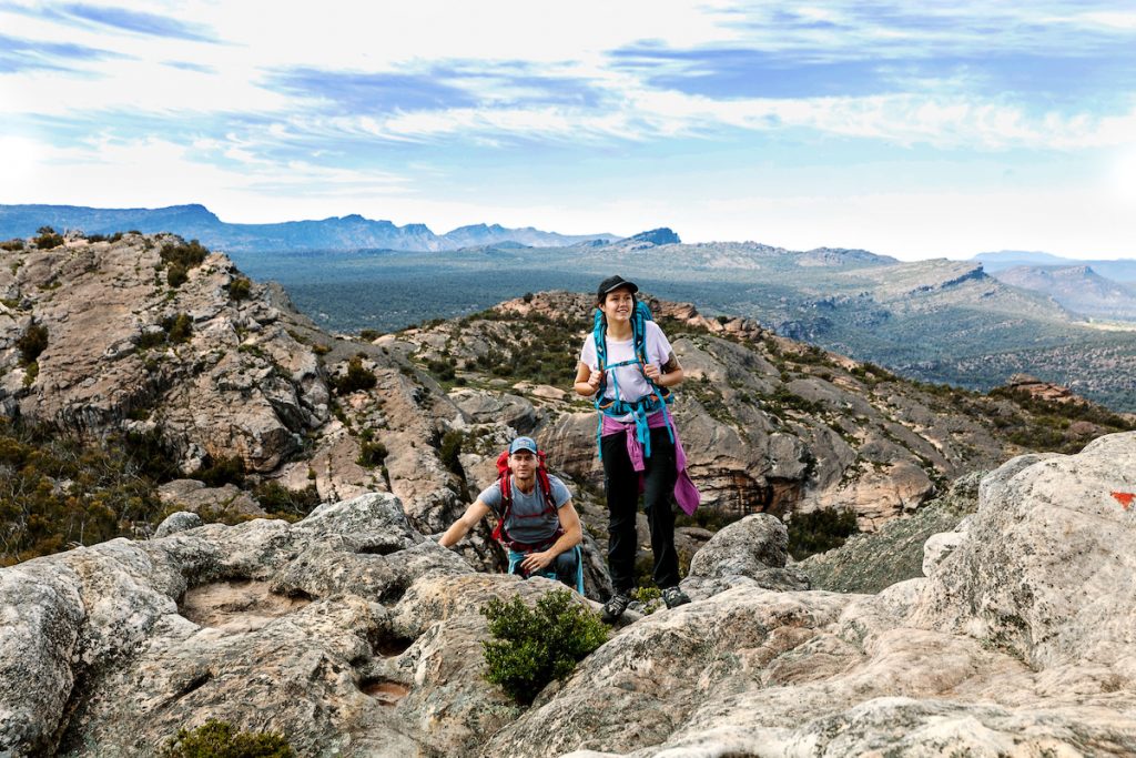
Grampians Peaks Trail – Official 3 Day Hike Options
The below 5 x 3 day hike options allow hikers to discover the Grampians Peaks Trail at a slower pace and the options run in order of the trail from the recommended north to south route.
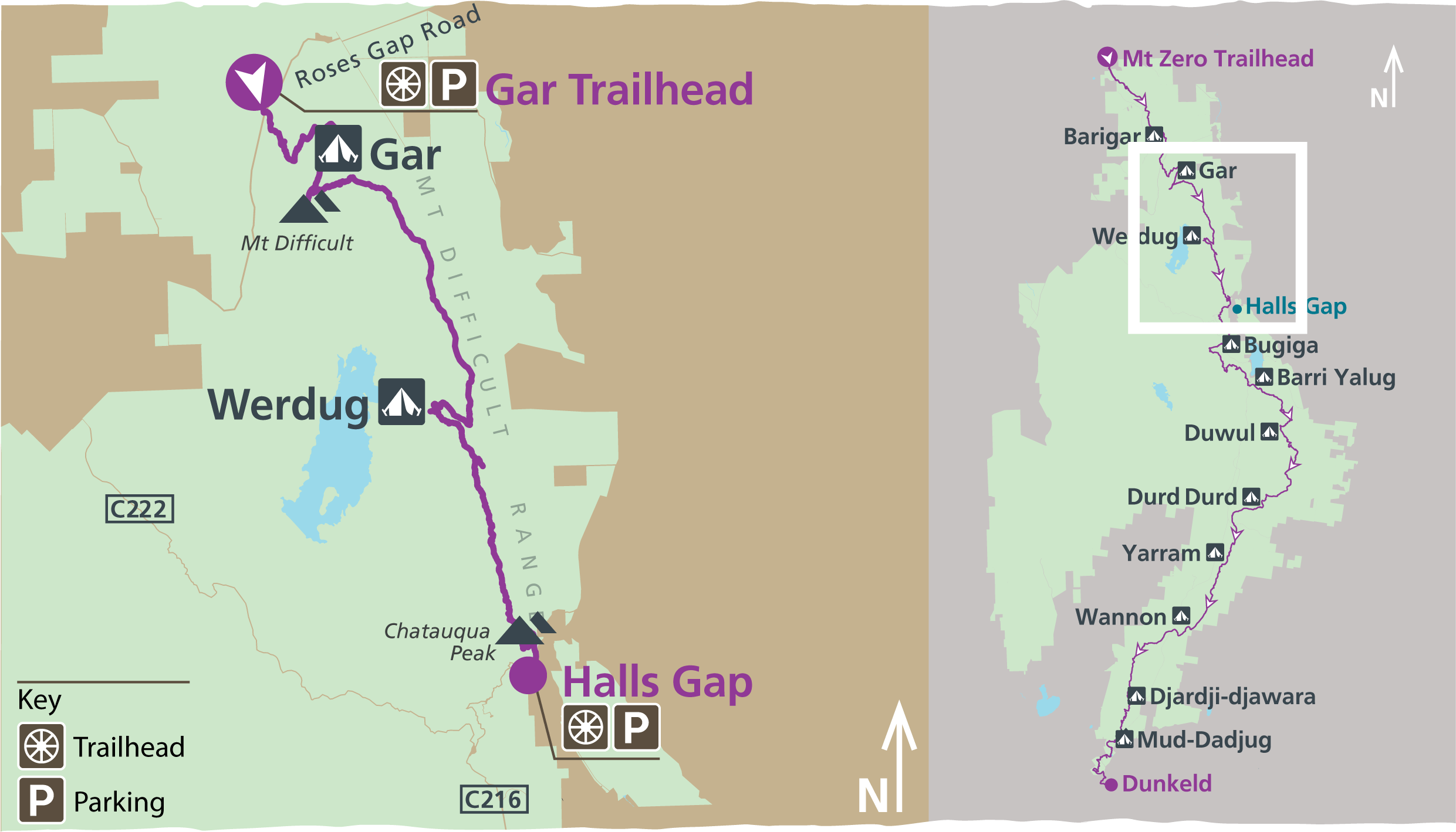
Hike No.1 – Gar & Werdug 3-Day Hike
This section of the trail is particularly spectacular in winter, spring and after rain, when clifftop rockpools and seasonal waterfalls are at their best. Gar (meaning “big mountain”) is the highest on the western side of the range, rewarding walkers with spectacular 360-degree views. Lake Wartook Lookout, at 829m, is one of the highest points on the eastern side of the Mount Difficult Range with sweeping 360-degree views of Gariwerd.
Day 1: Gar Trailhead (Roses Gap Road) to Gar Hike-in Campground (7.2 kilometres)
Begin your journey at the Gar Trailhead (Roses Gap Road). Along the 7.3-kilometre rugged, rocky adventure you’ll experience steep climbs and panoramic views including the seasonal waterfalls of Gar. As the trail zig zags upwards, uninterrupted views to the north are revealed. You will climb through stunted eucalypt forest, past boulders and over rocky slabs on the edge of the Mount Difficult escarpment taking in views over nearby mountains, Wartook Valley, Asses Ears and the Black Range (Burrunj). Arrive at the Gar Hike-in Campground, perched on a spectacular cliff top high above the valley below. You’ll be spending the night camped along the rocky terrace, perfect for watching the sunset.
Day 2: Gar Hike-in Campground to Werdug Hike-in Campground (14.1 kilometres)
From the hike-in campground, take a side trip to the rocky summit of Mount Difficult (Gar). Enjoy the sunrise before traversing south towards Lake Wartook along rocky ridgelines. The trail rises and falls over highpoints and through mountain saddles, before finishing on a high knoll at Werdug Hike-in Campground. The campground provides views over Lake Wartook and across the Mount Difficult Range.
Day 3: Werdug Hike-in Campground to Halls Gap (12.9 kilometres)
Start with a steady climb to Lake Wartook Lookout for spectacular views and a morning tea break. Enjoy the sweeping views to the North, west and southern of Gariwerd. To the west is Lake Wartook with Bear Island in the middle, the western Mount Difficult Range, Asses Ears and the Black Range (Burrunj) in the far distance. To the south, Mount William (Duwul) dominates the skyline, curving from The Sentinel at the northern tip around to the highest mountains in the park – Redman Bluff and including Mount William (Duwul) and the Major Mitchell Plateau massif. The Grampians Peaks Trail crosses these high mountains in the Duwul and Durd Durd 3-day Hike. Leaving the Lake Wartook lookout, make the descent passing rocky outcrops through lower vegetation with the last views over the Mount Difficult Range. Leaving the dry and rocky northern Grampians and moving onto the wetter eastern slopes, the trail gently descends through a canopy dominated by Messmate and Brown Stringybark with an open understorey featuring ferns, grasses, wattles and tea trees. Take a short detour to Chatauqua Peak (Bim) before descending through tall forest, rich with birdlife and wildflowers, completing your journey in Halls Gap.


Bookings and itinerary information
This 3-day hiking itinerary connects with the Barigar overnight hike to the north, as well as other connecting tracks to allow you to step on and off from various points throughout Gariwerd. If you are planning on staying longer to do more sections of the walk, you can add other itineraries to your booking. The trailhead for this itinerary is signposted with temporary car parking at Troopers Creek Campground and you can also find its location in the official maps for Grampians Peaks Trail. You can find out how to get there via the map above. All itineraries require a car shuffle from start to finish. If you only have one vehicle, please visit Brambuk the National Park and Cultural Centre for other pick-up or walk options.
Camping fees
The trail itself is free to hikers but camping fees apply to stay overnight. This itinerary includes two nights at two different, dedicated campgrounds: first night at Gar Hike-in Campground and second night at Werdug Hike-in Campground. These are booked as an all-inclusive itinerary – all you need to do is choose the date of your first night to book. We recommend booking your 3-day hike well in advance of your planned departure to ensure there is tent pad availability at each campground.
The 3-day itinerary costs are:
$95.40 for up to two people on a 3.5m x 3.5m standard tent pad, or
$113.60 for up to three people on a large tent pad.
Campground information
Both campgrounds have 3.5m x 3.5m timber tent platforms with steel chains that can be used to secure your tent. Additional guy rope may be needed for tent vestibules or tunnel style tents. Each campground has been individually designed the fit within the surrounding landscape. They feature an unpowered communal area for meal preparation, basic toilet facilities and water collection points. Mobile phone service is not available within the Wartook Basin, but you may get some along ridgelines and high points and lower elevations. The use of fuel stoves in all hike-in campgrounds is permitted but open campfires are not allowed.
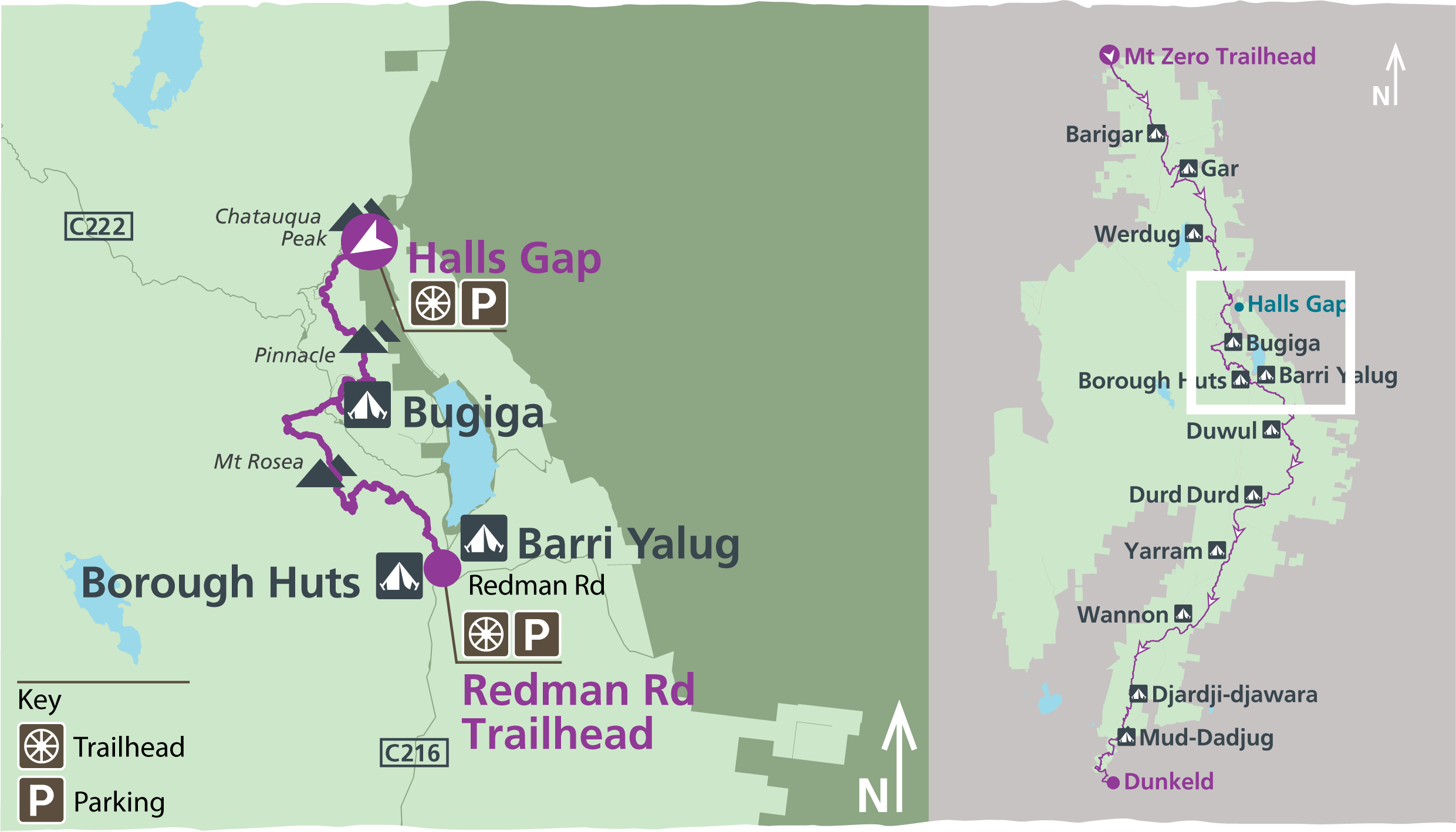
Hike No.2 – Bugiga & Barri Yalug 3 Day Hike
Travelling south from Halls Gap, the Bugiga and Barri Yalug 3-day hike takes in some of the most iconic natural attractions in the central Grampians such as Venus Baths, Grand Canyon, The Pinnacle, Sundial Peak and Mount Rosea. The track is an overall grade 4 walk, suitable for most hikers. Alternatively this area can be reached from the Tunnel Walk Trailhead via the Tunnel walk, Lake Bellfield track and connecting at Borough Huts Campground. All itineraries require a car shuffle from start to finish. If you only have one vehicle, please visit Brambuk the National Park and Cultural Centre for other pick-up or walk options.
Itinerary highlights
Ramble past boulders along the edge of Stony Creek then climb up through the Grand Canyon. Witness spectacular, panoramic views along the Mount William Range, Fyans Valley and dramatic cliff faces of Mount Rosea. Walk through wet sclerophyll forest, scramble over boulders and rocky outcrops. See heritage-protected, raised water fluming held up by dry stone pillars.
Day 1: Halls Gap to Bugiga campground (8.5 kilometres)
Start your journey from either your Halls Gap accommodation or Brambuk – The National Park and Cultural Centre. This section of the walk involves stone staircases and footbridge crossings, following along Stony Creek towards the summit of The Pinnacle. There are impressive views from the Pinnacle all the way to Lake View Lookout.
Day 2: Bugiga Hike-in Campground to Barri Yalug Hike-in Campground (15.2 kilometres)
Leaving Bugiga Hike-in Campground, you will start the steady climb through tall forest towards Mount Rosea, the most northern peak in the Serra Range. The cliffs on Mount Rosea are some of the highest on the trail. With a long descent that features a series of steep and windy steps to Borough Huts before reaching the Barri Yalug Hike-In Campground destination.
Day 3: Barri Yalug Hike-in Campground to Barney Creek and Redman Road (770 metres)
Leave Barri Yalug Hike-in Campground and make your way down stone steps to cross Barney Creek and finish your walk at Redman Road Trailhead where you can meet a vehicle transfer back to Halls Gap. Ensure you organise this before your walk. The Grampians Peaks Trail then continues from here with the Duwul and Durd Durd 3-day hike to Seven Dials, Redman Bluff, Mount William (Duwul) and Durd Durd. If you are planning on staying longer to do more sections of the walk, you can add other itineraries to your booking.
Bookings and itinerary information
This 3-day hike connects with other day walks and tracks to allow you to step on and off from various points throughout Gariwerd such as returning to Halls Gap, or adding an additional night at Borough Huts Campground. The trailhead for this itinerary is Halls Gap and access to the trail is signposted. Find out more about the central Grampians walks in the official map for Grampians Peaks Trail. You can find out how to get to Halls Gap via the map above. All itineraries require a car shuffle from start to finish. If you only have one vehicle, please visit Brambuk the National Park and Cultural Centre for other pick-up or walk options.
Camping fees
The trail itself is free to hikers but camping fees apply to stay overnight. This itinerary includes two nights at two different, dedicated campgrounds: first night at Bugiga Hike-in Campground and second night at Barri Yalug Hike-in Campground. These are booked as an all-inclusive itinerary – all you need to do is choose the date of your first night to book. We recommend booking your 3-day hike well in advance of your planned departure to ensure there is tent pad availability at each campground.
The 3-day itinerary costs are:
$95.40 for up to two people on a 3.5m x 3.5m standard tent pad
Campground information
Both campgrounds have 3.5m x 3.5m timber tent platforms with steel chains that can be used to secure your tent. Additional guy rope may be needed for tent vestibules or tunnel style tents. Each campground has been individually designed the fit within the surrounding landscape. They feature an unpowered communal area for meal preparation, basic toilet facilities and water collection points. Mobile phone service is not available at Bugiga Hike-in Campground and along some sections of the walk. There is good service at Barri Yalug Hike-in Campground. The use of fuel stoves in all hiker camps is permitted but open campfires are not allowed. Please take your rubbish with you on the entire journey and dispose of it when you get home.
Hike No.3 – Duwul & Durd Durd 3-Day Hike
Traversing an exposed montane landscape and the highest mountains in the park, the tough Duwul and Durd Durd 3-day Hike is an overall grade 5 track, suitable for experienced hikers. All itineraries require a car shuffle from start to finish.
Itinerary highlights
This itinerary has the greatest elevation of the trail and most challenging terrain, climbing to the Seven Dials, Redman Buff and Mount William (Duwul), the highest mountain in western Victoria. Experience a steep and rough descent into Boundary Gap and then a steep climb to Major Mitchell Plateau with some of the most spectacular views that are only accessible on foot.
Day 1: Redman Road to Duwul Hike-in Campground (12.4 kilometres)
This section of the walk has the greatest elevation change on the entire trail crossing Barney Creek at 320 metres and Redman Bluff at 1,017 metres with spectacular views of the Serra Range to the west. From Seven Dials, climb through rocky outlooks onto the ridgeline to the summit of Redman Bluff and continue from the summit downhill to the Duwul Hike-in Campground.
Day 2: Duwul Hike-in Campground to Durd Durd Hike-in Campground (14.5 kilometres)
Climb to Mount William (Duwul) with 360 degree views across Gariwerd. Descend into Boundary Gap and then roam across the exposed Major Mitchell Plateau with fantastic views of the Serra Range and eastern side of the park, before going down the Plateau to camp at the Durd Durd Hike-in Campground.
Day 3: Durd Durd Hike-in Campground to Jimmy Creek Road (5.7 kilometres)
Begin the long descent to Jimmy Creek Road, with views of the Mount William Range and Serra Range. This section is fantastic for wildflowers. Keep an eye out for the red “spider flowers” of Flame Grevillia (Grevillia dimorpha) which are typically in bloom between April and November.

Bookings and itinerary information
This 3-day hike connects with Bugiga and Barri Yalug 3-day Hike to the north and the Yarram and Wannon 3-day hike in the south. There is also a walking track junction to Kalymna Campground. The trailhead for this itinerary is Redman Road (see map location below). Find out more about the central Grampians walks in the official map for Grampians Peaks Trail.
Camping fees
The trail itself is free to hikers but camping fees apply to stay overnight. This itinerary includes two nights at two different, dedicated campgrounds: first night at Duwul Hike-in Campground and second night at Durd Durd Hike-in Campground. These are booked as an all-inclusive itinerary – all you need to do is choose the date of your first night to book. We recommend booking your 3-day hike well in advance of your planned departure to ensure there is tent pad availability at each campground.
The 3-day itinerary cost is $95.40 for up to two people on a 3.5m x 3.5m standard tent pad
Campground information
Campgrounds have a mix of 3.5m x 3.5m timber tent platforms and granite sand pads with steel chains that can be used to secure your tent. Additional guy rope may be needed for tent vestibules or tunnel style tents. Each campground has been individually designed the fit within the surrounding landscape. They feature an unpowered communal area for meal preparation, basic toilet facilities and water collection points. Mobile phone service good at both campgrounds and on higher elevations with line of sight to Halls Gap and Pomonal communication towers. The use of fuel stoves in all hiker camps is permitted but open campfires are not allowed.
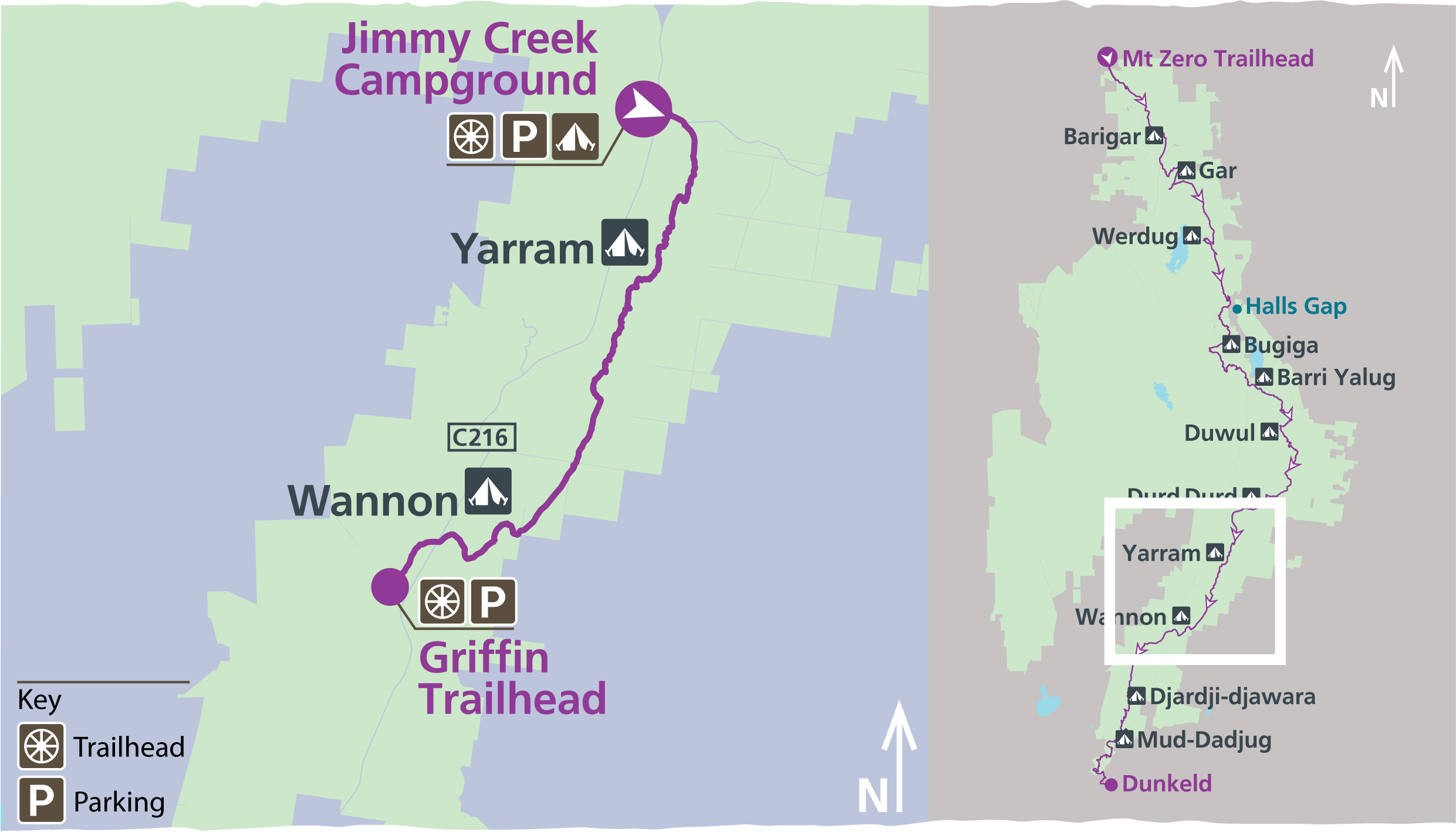
Hike No.4 – Yarram & Wannon 3-Day Hike
This itinerary provides amazing views over the Serra Range, hikes through rocky knolls, waterways, wetlands and open grassland camping.
Climb and descend a succession of six knolls and saddles passing through ancient old growth forests and lower swampland plains with stands of native Oyster Bay Pines along the way. Take in views of farmland to the east and south-east reveal a myriad wetlands.
Continue hiking the ups and downs of the most southern ridgeline of the Mt William Range and settle in at Wannon Hike-in Campground for the night in a reclaimed farmland gully. Explore surrounding ridges for stunning sunset views.
Day 1: Jimmy Creek Campground to Yarram Hike-in Campground (6.2 kilometres)
From the campground cross the road and climb up onto the Mt William Range and follow the range to its most southern extent. Enjoy views along the eastern slopes of farmland, small waterways and wetlands. The track passes through a gully and high cliffs to camp in a high saddle at Yarram Hike-in Campground.
Day 2: Yarram Hike-in Campground to Wannon Hike-in Campground (11.1 kilometres)
This day will take hikers down steeply to a gully and then onto the western edge of the range, with views of the jagged Serra Range. Continuing south uphill and then descend to cross Yarram Gap Road. From the trailhead traverse a succession of rocky knolls with views east, west and south across to Mt Abrupt to find your camp in an open, grass clearing at Wannon Hike-in Campground.
Day 3: Wannon Hike-in Campground to Griffin Fireline / Traihead (5.6 kilometres)
The final day of this itinerary takes hikers through a heavily forested saddle and slowly descends into open woodland and then grassland, to meet the Wannon River. Cross the river and follow the boardwalk that winds through wildflower-rich open woodland to the Grampians Tourist Road and then onto Griffin Fireline Trailhead.
Bookings and itinerary information
This 3-day hike connects with Yarram and Wannon 3-day hike to the north and continues south to the Djardi-djawara and Mud-dadjug 3-day hike. The trailhead for this itinerary is Jimmy Creek. Find out more about the central Grampians walks in the official map for Grampians Peaks Trail.
Camping fees
The trail itself is free to hikers but camping fees apply to stay overnight. This itinerary includes two nights at two different, dedicated campgrounds: first night at Yarram Hike-in Campground and second night at Wannon Hike-in Campground. These are booked as an all-inclusive itinerary – all you need to do is choose the date of your first night to book. We recommend booking your 3-day hike well in advance of your planned departure to ensure there is tent pad availability at each campground.
The 3-day itinerary cost is $95.40 for up to two people on a 3.5m x 3.5m standard tent pad.
Campground information
Campgrounds have a mix of 3.5m x 3.5m timber tent platforms and granite sand pads with steel chains that can be used to secure your tent. Additional guy rope may be needed for tent vestibules or tunnel style tents. Each campground has been individually designed the fit within the surrounding landscape. They feature an unpowered communal area for meal preparation, basic toilet facilities and water collection points
Patchy/poor mobile service between Yarram Hike-in Campground and Yarram Gap Road. Good service on the top of the range between Yarram Gap Road and Wannon Hike-in Campground. No service at Wannon Hike-in Campground. The use of fuel stoves in all hiker camps is permitted but open campfires are not allowed.
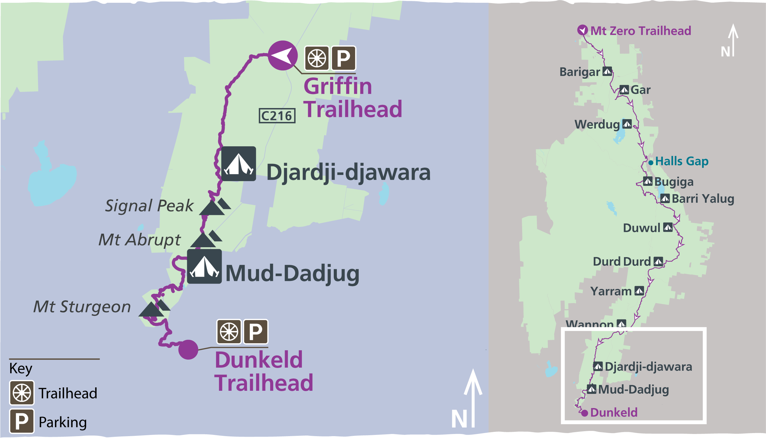
Hike No.5 – Djardji-Djawara & Mud-Dadjug 3-Day Hike
These new sections of trail pass through stunted eucalypt forest, the rocky mountain summits of Signal Peak and Mt Abrupt (Mud-Dadjug) hiking through old growth forested saddles and outstanding views west to the Victoria Range, climbing steeply to the summits of Signal Peak and Mt Abrupt (Mud-dadjug) and crossing Bainggug (The Piccaninny) and Mt Sturgeon (Wurgarri) before crossing the Wannon River and strolling into Dunkeld.
Day 1: Griffin Trailhead to Djardi-djawara Hike-in Campground (10.7 kilometres)
Starts at the Griffin Trailhead and climbs through stunted vegetation onto the Serra Range, with outstanding views west to the Victoria Range. Finish the day camping at Djardi-djawara Hike-in Campground below rocky outcrops.
Day 2: Djardi-djawara Hike-in Campground to Mud-Dadjug Hike-in Campground (7.9 kilometres)
This day’s hike alternates between rock steps and jumbles of boulders passing small cliffs and ledges that provide excellent vantage points. Hikers climb steeply to the summits of Signal Peak through a series of small heathy and forested saddles to Mt Abrupt, finishing with your camp at Mud-Dadjug high above the landscape.
Day 3: Mud-Dadjug Hike-in Campground to Dunkeld (14.8 kilometres)
This day crosses Bainggug (The Piccaninny) and Mt Sturgeon, before meandering through red gums, crossing the Wannon River and strolling into Dunkeld. Descend down one last rocky slope towards the farmland below, taking in stunning views out over volcanic plains and the impressive peaks of the southern Grampians from Mt Sturgeon (Wurgarri). To the north are the sedimentary sandstones of Gariwerd; to the south, basalt lava flows from volcanic plains.
Bookings and campground information
This 3-day hiking itinerary is the final section of the Grampians Peaks Trail, however you can book itineraries before it, as well as other connecting tracks to allow you to step on and off from various points throughout Gariwerd. The Griffin Trailhead is the starting point for this itinerary.
Camping fees
The trail itself is free to hikers but camping fees apply to stay overnight. This itinerary includes two nights at two different, dedicated hike-in campgrounds. You will stay your first night at Djardi-djawara Hike-in Campground and second night at Mud-dadjug Hike-in Campground. These are booked as an all-inclusive itinerary – all you need to do is choose the date of your first night to book. If you are planning on staying longer to do more sections of the walk, you can add other itineraries to your booking. We recommend booking your two nights of camping prior to embarking on the walk to ensure there is tent pad availability at each campground.
The 3-day itinerary cost is $95.40 for up to two people on a standard tent pad.
Campground information
Campgrounds either have timber tent platforms or granite sand pads. Tent platforms have steel chains that can be used to secure your tent. Additional guy rope may be needed for tent vestibules or tunnel style tents. Standard timber platforms and granite sand pads are 3.5m x 3.5m. Each campground has been individually designed the fit within the surrounding landscape. They feature an unpowered communal area for meal preparation, basic toilet facilities and water collection points. The use of fuel stoves in all hiker camps is permitted but open campfires are not allowed.
YOUR GUIDE – JONO INGRAM
Good Times Tours is my passion project and since 2015 I’ve had the pleasure of running over 50 hiking and camping tours to Victoria’s best National Parks including Wilson’s Promontory & the Grampians. I’m also a massive fan of Victoria’s Great Ocean Walk and wanted to deliver flexible and affordable hiking trips to small groups who are happy to camp and or stay in local accommodation. The 100km route offers approx. 60km of epic trail and by incorporating the drive down the Great Ocean Road, side trips into the Otways rainforest & finishing with visit’s to Victoria’s icons like the 12 Apostles I’m able to offer guests a really rich sightseeing and hiking experience. For interstate and overseas guests looking to maximise their sightseeing options, I also incorporate visits from the Great Ocean Road/Great Ocean Walk up to the Grampians and then back to Melbourne via the Grampians Wine Region. In late 2021 Victoria’s newest long distance hiking trail the Grampians Peaks Trail is due to open and I’ll be spending a significant amount of time hiking the entire length of the trail to put together the best itineraries possible for my guests which will include camping and accommodation options and return transport from Melbourne.
For Melbourne locals who enjoy a wine or two, you’ll be glad to know I’ve organised over 100 wine tours to Victoria’s regions including the Yarra Valley, Mornington Peninsula, Bellarine Peninsula, Heathcote, Macedon Ranges, Rutherglen and the King Valley, so you can have every confidence that I know where Victoria’s best cellar door experiences are and can accommodate a wine tour to suit your groups needs.